NEMAC

placeholder

UNC Asheville's Applied Research Center

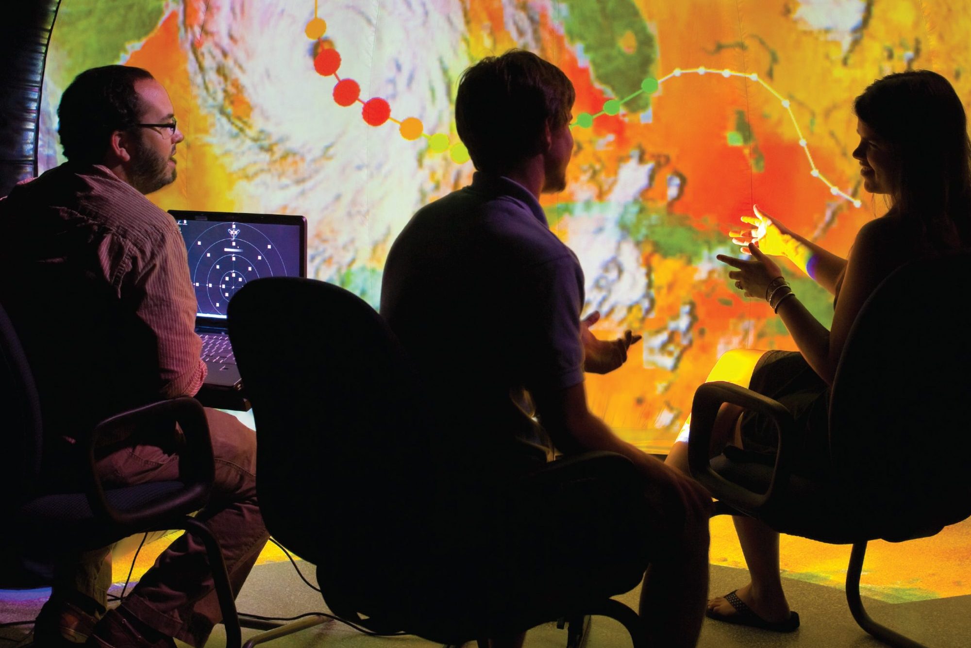
The National Environmental Mapping and Applications Center (NEMAC) is an applied research center at the University of North Carolina Asheville. Specializing in science communication and the development of decision support tools to enhance community and landscape resilience, our goal is to support our partners by serving as an effective bridge between science producers and science users. Our interdisciplinary team of expert science translators are driven to make science usable and accessible. NEMAC empowers our partners by creating data-driven products to ensure a more resilient future for all.


What We Do

placeholder

Data-Driven Approach

Our world is experiencing an unprecedented amount of climatic and environmental change, and we want to ensure that all communities and the natural environment are able to withstand and adapt to this change. We do this by providing data-driven tools to aid decision-making, including web applications, content management systems, interactive mapping applications, 3D visualizations, narrative content development, and workshop training.

placeholder

Strategic Planning

NEMAC has been guided by an unwavering commitment to improving decision-making related to climate and environmental change. Founded in 2003, our organization has evolved into a dynamic applied research center, dedicated to supporting and empowering communities to navigate the complex landscape of climate and environmental challenges.


NEMAC Programs

placeholder

Climate Resilience Toolkit

The U.S. Climate Resilience Toolkit is a one-stop website for people and communities seeking data-driven resources to understand and address climate risks. The Toolkit is a partnership between NEMAC and the National Oceanographic and Atmospheric Administration (NOAA).

placeholder

Community Resilience Assessments

Climate resilience is the ability of the natural, human, economic, and built systems to recover from and withstand impacts from weather and climate. NEMAC uses the NOAA Steps to Resilience framework to help cities and communities better understand and manage their climate risks, prepare for future impacts from extreme weather events, and build resilience for a better tomorrow.

placeholder

Coastal Resilience Assessments

NEMAC collaborates with the National Fish and Wildlife Foundation to identify and prioritize areas for coastal resilience and conservation projects that benefit both human and natural communities on all U.S. coasts, including Hawai’i, the Great Lakes, and all U.S. territories and commonwealths. The Assessments identify coastal areas where the implementation of nature-based solutions have the greatest potential to maximize benefits for both human community resilience and fish and wildlife habitat.

placeholder

The Climate Explorer

This interactive tool, co-developed by NEMAC, allows users to explore graphs and maps of historical and projected climate variables for any county and territory in the United States.

placeholder

Landslide Hazard Tools

NEMAC, in partnership with the North Carolina Geological Survey, developed a landslide hazard website and viewer to communicate landslide hazards in Western North Carolina.

placeholder

Forest Change Tools

Forest managers and scientists access a wealth of satellite data to monitor forest health in this suite of tools developed by NEMAC, the U.S. Forest Service, and North Carolina Forest Service.


Our Partners

At NEMAC, we don’t have clients; we have partners. Our strength is embedded in our ability to create strong and evolving relationships. Leveraging the resources and talents of government, education, non-profit, and private industry allows for projects that promote socio-economic development, support community resilience, and advance public education of regional and national level environmental issues. Building resilience can not be achieved alone, and we are grateful for the opportunity to collaborate with the following partners in our work.

placeholder

Biltmore

One of the most prominent historical attractions here in Asheville, the Biltmore Estate offers more than its famous architectural wonder. Home to flowering gardens and wooded trails leading to iconic views of the Blue Ridge Mountains, NEMAC is facilitating an analysis of these historic and protected areas, as well as the potential for future changes to the landscape.

placeholder

Buncombe County Government

Buncombe County and the City of Asheville have established ordinances specific to the development of land on steep inclines. In collaboration with the Buncombe County GIS office and Asheville GIS, the mapWNC slope calculation tool was created to determine the natural slope for parcels of land throughout the region.

placeholder

City of Asheville

The NEMAC team led City of Asheville staff through the “Steps to Resilience” training, a five-step climate-risk planning process. The resulting citywide resilience plan designed to address the effects of climate change was incorporated into Asheville’s 2018 comprehensive plan.

placeholder

Climate Interactive

Established in 2005, Climate Interactive is rooted in the fields of system dynamics modeling and systems thinking. This non-profit group creates and shares tools that drive effective and equitable climate action.

placeholder

Ecobot

Ecobot brings expertise together from decades in environmental consulting and enterprise software development to create technology so profoundly intuitive and impactful that everyone who does environmental fieldwork – or leads a team of field scientists – will want to use it.

placeholder

Fernleaf

Fernleaf Interactive is a climate solutions business startup that was launched from NEMAC’s applied research. Together we have established a public-private partnership that leverages the expertise of both groups by empowering communities and organizations to make the right investments for effective climate resilience and adaptation.

placeholder

Land of Sky Regional Council of Governments

This local group worked with NEMAC to develop a resilience plan for the region’s economic development and transportation assets. By following the “Steps to Resilience” from the U.S. Climate Resilience Toolkit, the resultant report revealed regional assets facing exposure from a changing environment.

placeholder

North Carolina Geological Survey

NEMAC collaborates with the North Carolina Geologic Survey (NCGS) to inform people about landslide hazards in western North Carolina through visualizations, an online map viewer, and guided online stories.

placeholder

Mountain Area Health Education Center

MAHEC excels at identifying innovative practices that increase training and foster retention among healthcare workers throughout Western North Carolina (WNC). NEMAC’s expertise in user research and GIS analysis supports MAHEC in providing up-to-date and useful data and information to WNC communities.

placeholder

National Fish and Wildlife Foundation

In collaboration with NFWF, NEMAC helped to develop Coastal Resilience Assessments for all U.S. coastlines and a supplemental web tool to interact with and understand the assessment data and results.

placeholder

National Oceanic and Atmospheric Administration

NEMAC partners with NOAA’s Technical Support Unit to create the National Climate Assessment Sandbox, a tool to help authors create figures for their respective chapters in the National Climate Assessment.

placeholder

National Integrated Drought Information System

Understanding complex and ever-changing data related to water availability is a task difficult to master by even the experts. NEMAC works with NIDIS to ensure that this information is displayed to its stakeholders effectively and efficiently.

placeholder

North Carolina Institute for Climate Studies

As an inter-institutional research institute of the University of North Carolina system, NCICS facilitates climate-related research across the UNC system and its partner organizations.

placeholder

North Carolina Department of Environmental Quality

NEMAC collaborates with the North Carolina Geologic Survey to inform people about landslide hazards in western North Carolina. Users can explore current and historical information about landslides across the region, and access resources to help plan for and build resilience to landslide hazards.

placeholder

North Carolina Forest Service

NEMAC and NCFS created the Southern Forest Area Change Tools (SouthFACT), which utilizes satellite imagery and additional GIS data to identify and quantify changes in forest cover in the Southeast.

placeholder

NOAA’s Climate Program Office

The U.S. Climate Resilience Toolkit, a Webby Award-nominated website is designed to help local governments build climate resilience. NEMAC and NOAA’s CPO developed and have continued to maintain and evolve the Toolkit.

placeholder

Southeast Sustainability Directors Network

In collaboration with SSDN and the University of Arkansas, NEMAC helped develop a program that provides education on community resilience planning, promotes network collaboration through workshops, and developed an online Community Resilience Planning Handbook for communities across the Southeast.

placeholder

Southern Group of State Foresters

The mission of SGSF is to provide leadership in sustaining the economic, environmental, and social benefits of the South’s forests. They work together to identify and address existing and emerging issues and challenges that are important to southern forests and citizens.

placeholder

The Water Institute of the Gulf

Similar to NEMAC, TWI is an interdisciplinary applied research institution and therefore, they are willing to think creatively and collaboratively, across fields of science and management agencies, to identify solutions to complex environmental and societal problems.

placeholder

Triangle J Council of Governments

NEMAC guided the Triangle Regional Resiliency Partnership in assessing, planning, and prioritizing resilience-building strategies.

placeholder

United States Global Change Research Program

NEMAC works with the USGCRP Climate Indicators team to develop static and dynamic graphics that help communicate key climate messages for the Global Change Indicator platform.

placeholder

U.S. Forest Service’s Eastern Forest Environmental Threat Assessment Center

NEMAC supports EFETAC in the development of ForWarn, a forest disturbance monitoring system, and LanDAT, a tool that aids stakeholders in understanding and incorporating landscape resilience and vulnerability into project planning.


New and Updates

Jim Fox to Discuss Community Resilience at OLLI on March 6

Jim Fox, NEMAC’s Director, will present a talk entitled Community Resilience Related to Climate: Moving from Research to Application on Wednesday, March 6, 2019, from 4:30–6:00 PM in Room 102 at UNC Asheville’s Reuter Center. The talk is part of the Osher Lifelong Learning Institute (OLLI)’s Interdisciplinary STEM Seminar Series.

One of the pillars of the U.S. Climate Resilience Toolkit is a process—the Steps to Resilience—that emphasizes a sequence of procedures and actions for local decision making. The process includes inventorying assets and their associated climate-related hazards; conducting exposure, vulnerability, and risk analyses; examining options to build resilience; and prioritizing climate adaptation decisions and investments prior to taking action. Although the steps are complex and may take months/years to do by hand, we have formed a public/private partnership and created a local small business to provide this service.

The work involves many aspects of STEM, including climate science, computer programming technology, process engineering, and the mathematics of analytics. The presentation will include examples about how communities nationwide are using the products and process from NEMAC+FernLeaf to be building community resilience. Join us to see how UNC Asheville’s NEMAC (National Environmental Modeling and Analysis Center) is working with FernLeaf Interactive to create local jobs and a rapidly growing enterprise here in Asheville.

Karin Rogers and Matt Hutchins to Speak at NCA4 Panel on February 21

The Collider will host the second in its two-part panel series focusing on the Fourth National Climate Assessment on Thursday, February 21, from 4:30 to 6:00 p.m. NEMAC’s Karin Rogers and Matt Huchins will join Tom Maycock, science public information officer with the North Carolina Institute for Climate Studies, and Jess Laggis, the Farmland Protection Director for the Southern Appalachian Highlands Conservancy, to identify some of the impacts climate change is having on cities and highlight the importance of conservancy in creating and maintaining climate resilience. For more information, see the press release published in the Mountain Xpress.


Our Team

Karin Rogers

NEMAC Director; Research Scientist

Office: 236 Rhoades/Robinson Hall
Phone: (828) 250-3892
Email: krogers@unca.edu

Karin Rogers

Greg Dobson, GISP

NEMAC Director of GIS and Engagement

Office: Office: 236 Rhoades/Robinson Hall
Phone: (828) 251-6973
Email: gdobson@unca.edu

Greg Dobson, GISP

Dave Michelson

NEMAC Chief Product Officer

Office: Hatch Coworking Suite 170
Phone: (828) 250-3890
Email: dmichels@unca.edu

Dave Michelson

Jessica Orlando

Geospatial Research Scientist; Natural Resources Specialist

Phone: 828-250-3890
Email: jorlando@unca.edu

Jessica Orlando

Ian Johnson

Senior Geospatial Analyst

Phone: 828-250-3890
Email: ijohnson@unca.edu

Ian Johnson

Ashlyn Dunsworth

Science Editor; Communications Manager

Phone: 828-250-3890
Email: ashore@unca.edu

Ashlyn Dunsworth

Jeff Bliss

Senior Software Developer

Office: 236 Rhoades/Robinson Hall
Phone: 828-250-3866
Email: jbliss@unca.edu

Jeff Bliss

Grace Chien

UX Designer

Phone: 828-250-3890
Email: gchien@unca.edu

Grace Chien

Cynthia Fountain

Administrative Associate, NEMAC/NCCHW/STEAM

Office: 236 Rhoades/Robinson Hall
Phone: 828-250-3890
Email: ckfounta@unca.edu

Cynthia Fountain

Dani Levy

Software Developer

Phone: 828-250-3890
Email: dlevy@unca.edu

Dani Levy

Gina Martinez

UX Designer

Phone: 828-250-3890
Email: gprovenc@unca.edu

Gina Martinez

Nora Ingram

Science Writer Intern, Atmospheric Science Major

Nora Ingram

Nereida Vidal

Marketing Intern, Psychology Major

Nereida Vidal

Our Student Interns

Nora Ingram

Science Writer Intern, Atmospheric Science Major

Nora Ingram

Nereida Vidal

Marketing Intern, Psychology Major

Nereida Vidal

Spring 2025 Internships

NEMAC and NCEI are hiring six UNC Asheville students for the Spring 2025 semester.

This is a unique opportunity to work with NOAA’s National Centers for Environmental Information (NCEI), the official U.S. data management entity for climatological, oceanographic, and geophysical information. NCEI operates one of the largest environmental data and information archives on Earth, ingesting, archiving, and disseminating information for users representing the breadth of society and economic sectors.


Stay Connected With Us

If you have any questions about the type of work that we do, the projects we’ve worked on, or career opportunities available, please send us a message.

Email: nemac@unca.edu


NEMAC on Campus

1 University Heights
236 Rhoades Robinson Hall, CPO#2345
Asheville, NC 28804

NEMAC at Hatch Innovation Hub

45 S French Broad Ave. Suite 170, Asheville, NC 28801
Directions to Hatch Innovation Hub
Available Free Parking